SOLS ON MARS
5,076
ACTIVE INSTRUMENTS
4
POLYGON HYPOTHESES
3+
MISSION DURATION
~14 yrs
NASA's Curiosity rover has wrapped up weeks of intensive drilling and sample analysis at the "Basque Lakes" and "Nazca" sites and is back on the move, climbing higher into Mount Sharp's layered geological record. The immediate science target: recurring polygonal rock textures that the team first encountered months ago at a lower elevation and have now reappeared on the ascent toward the Yardang unit.
Extraction Map
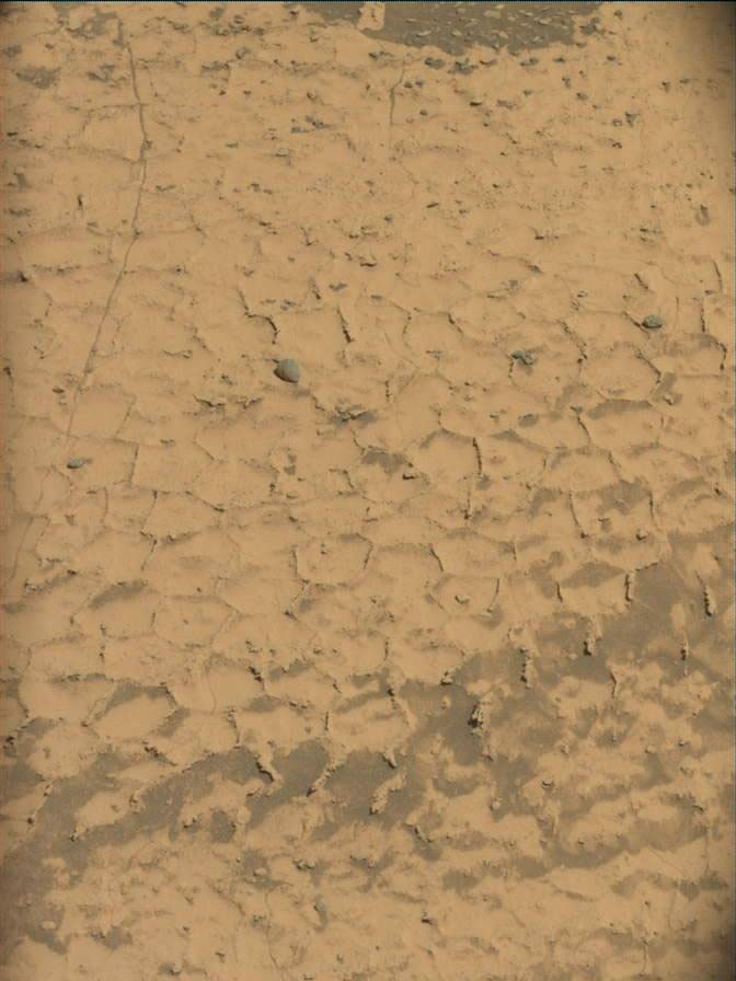
The polygons are small, regular in size, and bordered by raised ridges — a texture that caught the team off guard when first observed. The science team has been debating formation mechanisms. Candidates include mineral shrinkage from water loss, thermal cycling, or compaction-and-expansion events tied to burial and later exposure. Each mechanism points to a different chapter in Mars' environmental history, and distinguishing between them matters for understanding the planet's habitability arc. Curiosity is now using its less resource-intensive instruments — APXS, ChemCam, MAHLI, and Mastcam — to document rock chemistry and textures while maintaining upward progress. The composition of the cement forming the raised ridges around the polygons is a specific target. That chemistry could help narrow which of the competing formation hypotheses best explains the pattern. Deputy Project Scientist Abigail Fraeman notes that orbital imagery of the upcoming route shows layers with textures very similar to the original polygon field, suggesting the formations may become more dramatic and expansive over the next several drives. This is an educated guess, not a certainty — Fraeman is explicit that after 5,000-plus sols, Mars routinely surprises. The broader scientific logic is stratigraphic: climbing Mount Sharp is climbing through time. Each layer records a different environmental regime. The reappearance of polygonal textures at a new elevation means either the same process operated across multiple periods or the rover is intersecting the same geological unit at a different point. Distinguishing these scenarios requires exactly the kind of systematic chemistry-and-texture documentation Curiosity is now conducting. This is incremental, methodical planetary science — no breakthrough announcement, no dramatic finding. What it represents is the accumulation of contextual data that makes future breakthroughs interpretable. The polygon observations feed directly into reconstructing how water, temperature, and burial depth varied over geological time on Mars, which is the central question driving Curiosity's extended mission. Sol 5,073's MastCam image, captured at 15:45:05 UTC on the Martian surface, shows the polygon field clearly. The rover is now past Sol 5,076, with the Yardang unit on the upper reaches of Mount Sharp as the medium-term destination.
Worth reading?
ESSENTIAL
Score
84
/100
Generative — publicly funded science producing open-access geological data about Mars' habitability history, with no extraction or value capture by private actors.
What Is GRIN?
GRIN stands for Generativity, Resilience, Innovation efficiency, and Novelty openness. These four dimensions capture the essential characteristics of any memetic intelligence — whether a nation, a corporation, a religion, or a movement.
About GRINGenerativity
4/5
Resilience
4/5
Efficiency
4/5
Novelty
4/5
Extractive
0/5
Inverted
Does this create new capability or just redistribute existing value?
Pure knowledge generation. Each sol adds stratigraphic data to an open scientific record that any researcher on Earth can use to reconstruct Mars' environmental history.
Verified Facts (6)
Curiosity used its Mast Camera (MastCam) to capture this image on Sol 5073, or Martian day 5,073 of the Mars Science Laboratory mission, at 15:45:05 UTC
Written by Abigail Fraeman, Deputy Project Scientist, Jet Propulsion Laboratory, California Institute of Technology
Earth planning date: Friday, Nov. 13, 2026
Curiosity's past several weeks have been very focused on drilling and analysis of the 'Basque Lakes' and 'Nazca' samples
Polygonal textures like these can form under a variety of different conditions including shrinkage of the surface when water is lost from minerals, temperature cycling, or compaction and expansion after being buried and exposed
instruments like APXS, ChemCam, MAHLI, and Mastcam to document the chemistry and textures of the rocks
More latest news
Read all