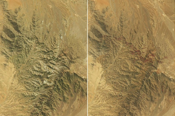
The Atacama Desert is one of Earth's driest landscapes — parts of it receive less rainfall in a decade than London gets in a day. So when the desert erupts in color, it means something large shifted in the climate machinery. In austral winter 2026, that machinery was El Niño, and the result is what researchers at Pontificia Universidad Católica de Valparaíso are calling the most significant desierto florido since remote sensing began. The mechanism is straightforward but the execution was extreme. As El Niño strengthened in the tropical Pacific, it weakened the subtropical Pacific high that normally keeps the Atacama bone-dry, while a blocking high near southern South America shoved the storm track equatorward. Beginning mid-July, an atmospheric river fed a series of storm fronts that brought one of the heaviest July rain events in decades across a long stretch of Chile, from the Atacama region south to Los Lagos. August followed with back-to-back winter storms that blanketed parts of the desert in rare snow. What happened next is visible from orbit. Landsat 8 and Landsat 9 captured the desert on September 14 and October 24 respectively, and the difference is startling. By September, green hillsides capped with white had appeared — blooms of suspiros (Nolana, probably Nolana baccata). By October, vast red-purple carpets of pata de guanaco (most likely Cistanthe longiscapa) had spread across the landscape roughly 30 kilometers southwest of Copiapó, near Desierto Florido National Park. The science team — Roberto Chávez, Matías Pérez-Evens, and Andres Moreira-Muñoz among them — deployed satellite data, drones, and digital cameras to map the bloom's biodiversity across space and time. The goal is practical: informing land-use planners and conservation managers about a phenomenon that is spectacular but ephemeral. A 2019 study using NASA's long-term vegetation record identified 13 Atacama blooms between 1981 and 2015, but Moreira-Muñoz says the 2026 event exceeds all of them in extent, intensity, and duration. This is NASA's Earth Observatory doing what it does best: pairing stunning imagery with the atmospheric physics that explain it, then connecting the visually beautiful to ongoing scientific fieldwork. The satellite comparison format — September left, October right — is simple and devastating. You don't need to read the caption to understand that something extraordinary happened between those two dates. The Atacama bloom also illustrates a quieter point about remote sensing's growing role in ecology. The 2014 study that mapped flowering and fog-fed plants around the Copiapó dune field used Landsat. The 2019 study used GIMMS NDVI time series. The current fieldwork integrates multispectral remote sensing with ground-truth photography. Each generation of study gets more granular, turning a phenomenon that was previously documented by anecdote into something measurable, comparable, and trackable across decades. Whether the 2026 bloom signals a trend or remains a one-off El Niño spectacular is an open question. What's not open: this is the most visually arresting Earth Observatory feature in recent memory, and the science underneath it is real.
Worth reading?
RECOMMENDED
Score
60
/100
Anyone who responds to dramatic landscape imagery backed by atmospheric science — remote sensing enthusiasts, climate watchers, ecology-curious readers, and anyone who wants to understand what El Niño actually does on the ground.
Cultural Placement
Like a National Geographic photo essay crossed with the explanatory rigor of Quanta Magazine, delivered through NASA's Earth Observatory format — comparison satellite imagery with field-science context. It sits in the tradition of the best EO Image of the Day features, which at their peak combine the visual punch of landscape photography with the causal clarity of an atmospheric physics explainer. Think of it as the science communication equivalent of a well-composed before-and-after architectural photograph: the drama is in the delta, and the craft is in choosing the right two moments to compare.
Honest assessment
This is a beautifully executed Earth Observatory feature that pairs some of the most striking Landsat imagery in recent memory with solid atmospheric and ecological context. It doesn't push the form forward, but it doesn't need to — the subject matter carries the piece. Worth your five minutes if you care about Earth systems, remote sensing, or just want to see a desert turn purple from space.
What Is NOVEL?
60
/ 100
BedrockNews applies a structured analytical framework called NOVEL to cultural works — games, books, film, music, and more.
How NOVEL worksNerve
2/5
Originality
3/5
Voice
3/5
Endurance
4/5
Lineage
3/5
What did the artist risk? What could have failed?
Low risk within a proven format. The EO Image of the Day template is well-established; the team executed it cleanly but didn't push against the form's boundaries or attempt anything structurally new.
Verified Facts (10)
Parts of the Atacama Desert in northern Chile turned red-purple, green, and white in austral spring 2026 following an unusually wet winter
Scientists say may be the most extensive desierto florido of the satellite era
Beginning in mid-July, a series of storm fronts fed by an atmospheric river brought one of the heaviest July rain events in decades
In August, back-to-back winter storms blanketed parts of the Atacama Desert in rare snow
Red-purple areas are vast blooms of pata de guanaco, most likely Cistanthe longiscapa or another Cistanthe species
About 30 kilometers (20 miles) southwest of Copiapó, near the eastern sector of Desierto Florido National Park
A 2019 study used NASA's long-term vegetation record to identify 13 Atacama Desert blooms between 1981 and 2015
This instance of the 'blooming desert' phenomenon appears to be the most significant to date—in terms of its extent, intensity, and duration
OLI on Landsat 8 acquired the September images, and the OLI on Landsat 9 acquired the October images
The green areas capped with white are blooms of suspiros, or Nolana, probably Nolana baccata
More latest news
Read all