YEARS · LANDSAT OPS
50+
EROS CONCEIVED
1966
GEMINI XII MISSION
4 days
PHOTO → PROGRAM
3 yrs
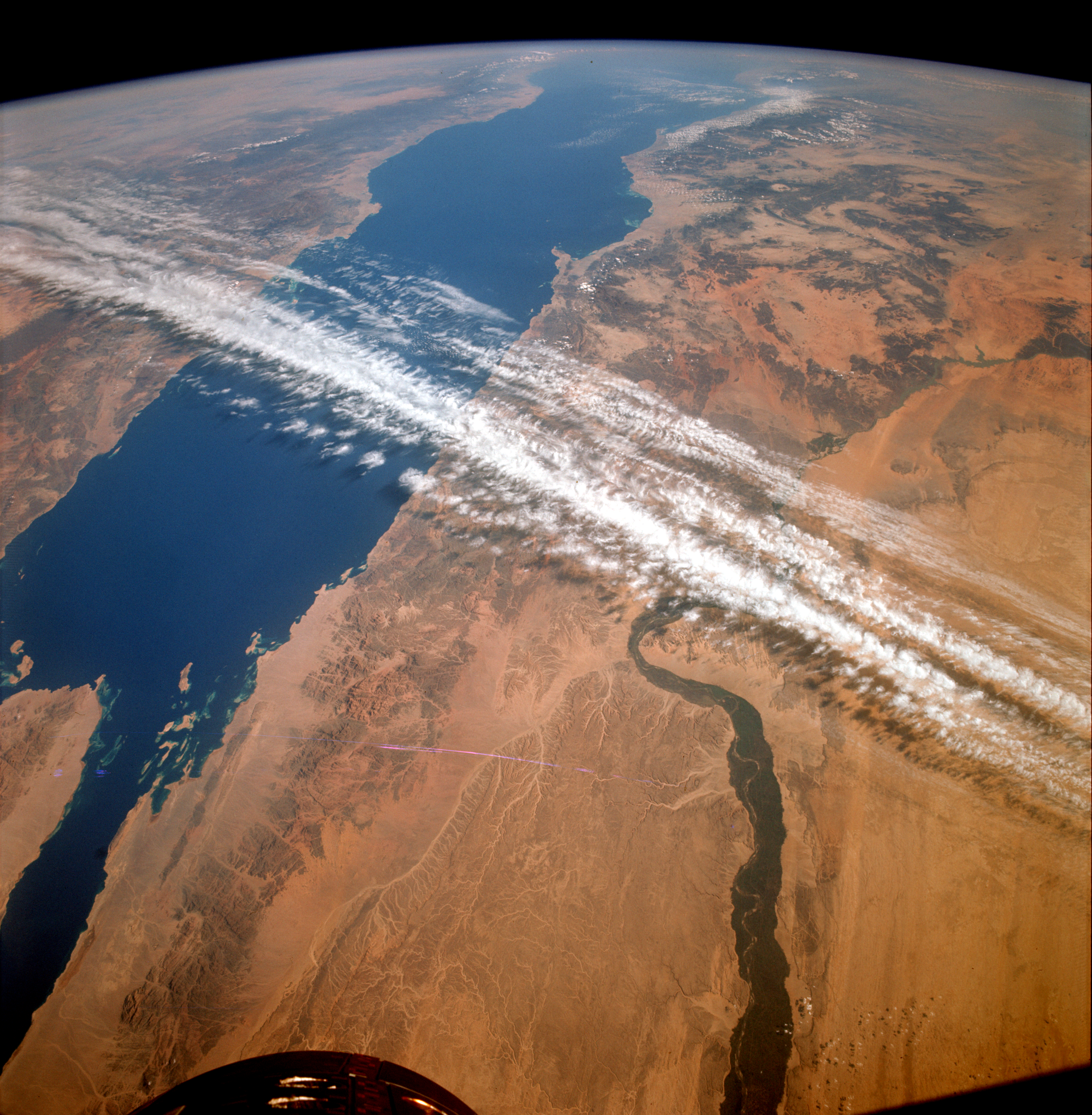
On November 14, 1966, astronauts James A. Lovell Jr. and Edwin E. "Buzz" Aldrin Jr. photographed the Red Sea and Nile river valley from orbit during Gemini XII, the final mission of NASA's Gemini program. The image was not a vanity shot. It was evidence.
Extraction Map
Gemini XII's four-day mission from November 11-15, 1966, had primary objectives — rendezvous maneuvers and spacewalks essential for the Apollo lunar program. But the orbital photography conducted by Lovell, Aldrin, and crews on earlier Gemini flights was quietly building a different case: that space could be used to study Earth itself, not just leave it. The person who weaponized that evidence was William T. Pecora, director of the United States Geological Survey from 1965 to 1971. Pecora championed the Earth Resources Observation Satellite (EROS) program, and in a 1969 statement made the lineage explicit: EROS was "conceived in 1966 largely as a direct result of the demonstrated utility of Mercury and Gemini orbital photography to Earth resource studies." The institutional chain is direct and traceable. Gemini photography proved that orbital imagery had scientific and resource-management value. Pecora used that proof to build political support for EROS. EROS paved the way for Landsat, which launched in 1972 and has operated continuously for more than five decades — the longest-running satellite Earth observation program in history. Landsat and its successors now provide data used worldwide to monitor crops, wildfires, flooding, vegetation health, land use, and other planetary changes. The entire global Earth observation infrastructure — commercial, governmental, and scientific — traces part of its institutional legitimacy back to astronauts pointing Hasselblads out spacecraft windows. The pattern here is worth naming: a capability developed for one purpose (lunar mission preparation) generated proof-of-concept data for an entirely different domain (Earth science). The generative leap was not the photography itself but the institutional actor — Pecora — who recognized the photographs as evidence for a policy argument and moved on it within three years. Sixty years later, the downstream value of that institutional move is incalculable. Every wildfire tracked by satellite, every crop yield estimated from orbit, every climate dataset built on Landsat imagery connects back to a moment when someone looked at astronaut snapshots and saw not souvenirs but infrastructure.
Worth reading?
ESSENTIAL
Score
92
/100
Generative — a secondary byproduct of the Gemini program created an entirely new field of Earth observation, generating public-good data infrastructure that has compounded in value for 50+ years.
What Is GRIN?
GRIN stands for Generativity, Resilience, Innovation efficiency, and Novelty openness. These four dimensions capture the essential characteristics of any memetic intelligence — whether a nation, a corporation, a religion, or a movement.
About GRINGenerativity
5/5
Resilience
4/5
Efficiency
5/5
Novelty
4/5
Extractive
0/5
Inverted
Does this create new capability or just redistribute existing value?
Textbook generativity. A byproduct of lunar prep — astronaut photos — became proof-of-concept for a planetary monitoring system now used by every nation on Earth.
Verified Facts (6)
NASA astronauts James A. Lovell Jr. and Edwin E. "Buzz" Aldrin Jr. captured this image of the area surrounding the Red Sea and Nile river valley on November 14, 1966
Gemini XII was the final flight of NASA's Gemini Program
Astronauts orbited Earth from November 11 to 15, 1966, on Gemini XII
William T. Pecora, the director of the United States Geological Survey from 1965 to 1971
Pecora noted that the Earth Resources Observation Satellite (EROS) program was "conceived in 1966 largely as a direct result of the demonstrated utility of Mercury and Gemini orbital photography to Earth resource studies"
For more than five decades, Landsat and other Earth-observing satellites have provided invaluable data used around the world to monitor crops, wildfires, flooding, vegetation health, land use
More latest news
Read all