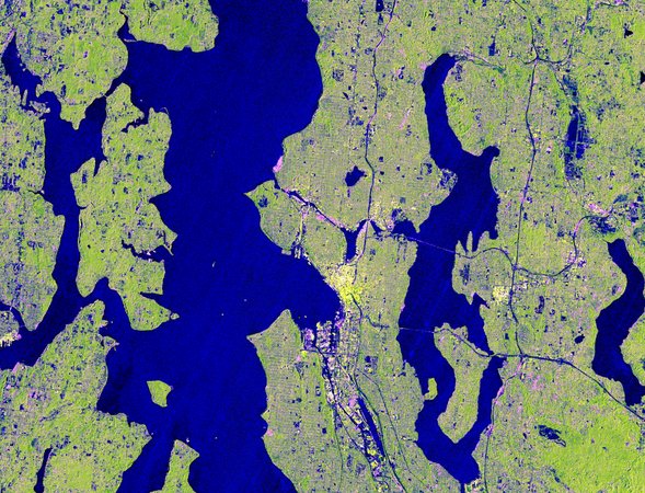
NASA has released new imagery from NISAR — the NASA-ISRO Synthetic Aperture Radar satellite — showing the Pacific Northwest in detail that includes Seattle, Portland, Mount Rainier, and Mount St. Helens. The source material is a single-sentence caption, but the instrument behind it is worth understanding because it represents one of the most significant Earth-observation capabilities ever deployed. NISAR is described as the most powerful radar system ever launched by NASA or ISRO (the Indian Space Research Organisation). That claim matters because synthetic aperture radar (SAR) does something optical satellites cannot: it sees through clouds, smoke, and darkness. The Pacific Northwest is one of the cloudiest regions in North America. An optical satellite trying to image Seattle would spend most of its passes staring at overcast. NISAR doesn't care. Radar sends its own signal and reads the return — weather is irrelevant. The mission is a joint effort between NASA and ISRO, making it one of the most significant US-India space collaborations to date. NISAR carries two radar bands — L-band (NASA-provided) and S-band (ISRO-provided) — which penetrate different depths of vegetation, ice, and soil. The dual-band design is what makes NISAR uniquely capable: L-band penetrates forest canopy to map ground deformation beneath trees, while S-band captures surface features at higher resolution. Together, they enable measurement of land surface changes at centimetre-scale precision across the entire globe, every 12 days. The choice of the Pacific Northwest as showcase imagery is not accidental. The region contains nearly every phenomenon NISAR was built to monitor: volcanic activity (Mount Rainier and Mount St. Helens are active Cascade volcanoes), earthquake risk (the Cascadia Subduction Zone), glacier and snowpack change, urban subsidence, and forest biomass. A single image of this region exercises most of the satellite's mission objectives simultaneously. Mount Rainier is considered one of the most dangerous volcanoes in the United States — not because an eruption is imminent, but because its glaciated slopes sit directly above the Seattle-Tacoma metropolitan area, and any significant volcanic or seismic event could trigger lahars (volcanic mudflows) that would reach populated areas within hours. NISAR's ability to detect centimetre-scale ground deformation on Rainier's flanks, through cloud cover, on a 12-day repeat cycle, is exactly the kind of persistent monitoring that volcanic hazard assessment requires. Mount St. Helens, which erupted catastrophically in 1980, remains actively monitored for the same reasons.
Worth reading?
OPTIONAL
Score
58
/100
What Is What to Watch?
What to Watch highlights the specific signals, decisions, or events that will determine which direction this story goes next.
About GRINNISAR'S FULL COMMISSIONING
NISAR's full commissioning and operational data release — the satellite is still in early operations; watch for the first systematic global datasets, expected later in 2025, which will establish the mission's actual measurement precision
CASCADIA SUBDUCTION ZONE
Cascadia Subduction Zone monitoring — NISAR's repeat-pass interferometry will build the most detailed map ever made of ground deformation along the Pacific Northwest coast; early results could refine earthquake risk estimates
US-INDIA SPACE COOPERATION
US-India space cooperation trajectory — NISAR's success or failure will influence whether NASA and ISRO pursue follow-on joint missions, particularly as India's space programme rapidly scales
Verified Facts (2)
Seattle, Portland, Mount Ranier, and Mount Saint Helens are captured in new imagery from NISAR
the most powerful radar system ever launched by NASA or ISRO
Solution Focus (4)
NISAR is described as the most powerful radar system ever launched by NASA or ISRO — a joint US-India mission carrying dual L-band and S-band synthetic aperture radar
Radar sees through clouds, smoke, and darkness — critical for the Pacific Northwest, one of the cloudiest regions in North America, where optical satellites are frequently blind
The imagery captures Seattle, Portland, Mount Rainier, and Mount St. Helens — a region that exercises nearly every NISAR mission objective: volcanism, seismic risk, glaciers, forests, urban subsidence
Mount Rainier's glaciated slopes above the Seattle-Tacoma metro area make it one of the most dangerous volcanoes in the US — NISAR's centimetre-scale deformation monitoring is precisely what hazard assessment needs
Community Actions (3)
NISAR's full commissioning and operational data release — the satellite is still in early operations; watch for the first systematic global datasets, expected later in 2025, which will establish the mission's actual measurement precision
Cascadia Subduction Zone monitoring — NISAR's repeat-pass interferometry will build the most detailed map ever made of ground deformation along the Pacific Northwest coast; early results could refine earthquake risk estimates
US-India space cooperation trajectory — NISAR's success or failure will influence whether NASA and ISRO pursue follow-on joint missions, particularly as India's space programme rapidly scales
More latest news
Read all