SNOW · DONNER PASS
~12"
FORECAST · 8K FT
4 ft
BARE → BLANKETED
48 hrs
WARNING THRESHOLD
5,000 ft
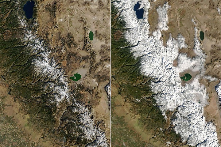
California's Sierra Nevada shifted from bare rock to winter landscape in 48 hours. On November 13, 2026, a moisture-laden Pacific storm dropped nearly 12 inches of snow at Donner Pass and 9 to 13 inches at Mammoth Mountain, with heavy rain flooding lower elevations around Sacramento. The storm closed Interstate 80 in both directions and forced road closures in Yosemite National Park.
Extraction Map
NASA's Terra satellite captured the transformation via its MODIS instrument. Images from November 12 show mountains mostly bare with snow only at the highest peaks. By November 14, during a brief lull between systems, fresh white blanketed the entire range. The before-and-after pair is a clean visual document of how fast Sierra hydrology can shift gears. This was not a one-off event. The National Weather Service issued a winter storm warning for Sierras above 5,000 feet from November 18 to 20, warning of snow accumulations up to 4 feet above 8,000 feet, gusty winds, and difficult-to-impossible travel conditions. The storm is part of a quick succession of Pacific systems hitting the U.S. West in mid-November. For California's water system, early Sierra snowpack is the headline metric. The state's reservoirs, agriculture, and urban supply chains depend on snowmelt. After years of drought-flood whiplash, any substantial early-season accumulation recalibrates the water year outlook. The Central Sierra Snow Laboratory at Donner Pass — which has tracked snowfall since 1946 — recorded the 12-inch dump, anchoring the measurement in one of the longest continuous records in the West. The infrastructure story is immediate and familiar: I-80 over Donner Summit is the primary east-west freight and commuter corridor between Sacramento and Reno. A single storm shutting it in both directions exposes the fragility of a mountain-pass transport network that has no real alternative route at comparable capacity. Yosemite's preemptive road closures follow the same logic — there is no redundancy. The generative value here is straightforward: snowpack is stored water. Every inch that accumulates above 8,000 feet is deferred runoff that feeds rivers, reservoirs, and aquifers through spring and summer. The question is whether the succession of storms builds a durable snowpack or delivers a burst that melts early in a warm spring — a pattern that has become more common as temperatures climb. NASA's MODIS data, distributed through the EOSDIS LANCE and Worldview systems, provides the observational backbone. This is public-domain Earth science infrastructure doing exactly what it was built for: giving policymakers, water managers, and the public near-real-time visibility into conditions that drive billion-dollar resource decisions.
Worth reading?
RECOMMENDED
Score
72
/100
Generative — snowpack accumulation is literal stored value for California's water system, and NASA's open MODIS data provides a public good with near-zero friction costs.
What Is GRIN?
GRIN stands for Generativity, Resilience, Innovation efficiency, and Novelty openness. These four dimensions capture the essential characteristics of any memetic intelligence — whether a nation, a corporation, a religion, or a movement.
About GRINGenerativity
4/5
Resilience
3/5
Efficiency
4/5
Novelty
2/5
Extractive
0/5
Inverted
Does this create new capability or just redistribute existing value?
Snowpack is deferred water supply — every inch above 8,000 ft feeds agriculture, reservoirs, and cities through summer. Early accumulation is genuine value creation for the state's water economy.
Verified Facts (8)
Nearly 12 inches (30 centimeters) of snow fell at Donner Pass, northwest of Lake Tahoe, on November 13
Mammoth Mountain reported 9 to 13 inches (23 to 33 centimeters) of new snow
Officials closed Interstate 80 in both directions that evening
NWS issued a winter storm warning for portions of the Sierras above 5,000 feet (1,500 meters) in elevation from November 18 to 20
Snow accumulations of around 4 feet (120 centimeters) possible above 8,000 feet (2,400 meters)
MODIS on NASA's Terra satellite captured the image on November 14
Officials at Yosemite National Park closed several roads ahead of the storm
Central Sierra Snow Laboratory recorded the snowfall
More latest news
Read all