RESERVOIR RISE
~60 ft
AVG CAPACITY · NOV 7
108%
PRECIP VS AVERAGE
2-4×
RAIN · PAGOSA SPRINGS
5.05 in
Back-to-back extreme rain events slammed the Four Corners region in late October and early November 2026, delivering 2 to 4 times the average precipitation across southwest Colorado, southeast Utah, northern Arizona, and northwest New Mexico. The storms ended short-term drought conditions across the Southwest and Great Basin — but the relief came violently, with record or near-record river flooding that forced evacuations and damaged property in multiple communities.
Extraction Map
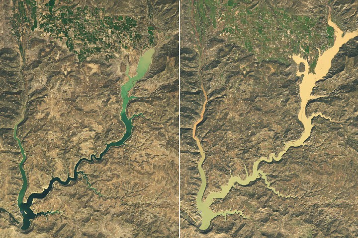
The most dramatic visible signal: Navajo Reservoir in northern New Mexico and southern Colorado rose nearly 60 feet (18 meters) between September 20 and November 7, according to U.S. Army Corps of Engineers data. Landsat 9 imagery captured the transformation. The reservoir went from holding just 60 percent of its average capacity for the date to 108 percent — its highest level since August 2019. The Bureau of Reclamation had decreased releases from Navajo Dam on September 16 and 17, amplifying the accumulation. The human cost concentrated along river corridors. Pagosa Springs, Colorado, a town on the San Juan River about 40 miles northeast of the lake, took the worst hit. The first storm dropped 5.05 inches (12.8 cm) of rain, pushing the San Juan to major flood stage on October 23. A second round drove the river to spike again on November 1, nearly matching the record set in 1911 during a devastating flood. Officials issued evacuation orders and responders rescued dozens of people as water inundated streets and damaged property. The underlying cause is structural vulnerability compounded by climate whiplash. Snow drought across the West in winter 2025-26 left reservoirs depleted heading into summer — Lake Powell hit record lows under the same conditions. Then an El Niño pattern steered moisture-laden storms across the Southwest interior at unusually low latitude for the time of year, drawing energy from record-warm ocean temperatures. The result was too much water, too fast, into a landscape already stressed by too little. The U.S. Drought Monitor confirmed the payoff: its November 3 summary declared that "short-term drought has ended for the Southwest and Great Basin." But long-term drought persists in places, and the mechanism of delivery — extreme precipitation rather than steady snowpack — is precisely the pattern that climate models have projected for the region. Water arrives in destructive bursts rather than the slow snowmelt that reservoir systems were designed to capture. This is the core tension the Southwest faces going forward. Infrastructure built for gradual spring snowmelt now absorbs violent autumn deluges. Navajo Reservoir's 60-foot surge looks like abundance on a satellite image, but the flooding in Pagosa Springs shows the cost of receiving a season's worth of water in days. The system got what it needed — through a delivery mechanism it was never designed to handle. The El Niño pattern currently underway increases the likelihood of continued moisture-laden storms being steered across the interior Southwest. Whether subsequent events build reservoir storage or simply generate more flood damage depends on timing, intensity, and the capacity of aging infrastructure to buffer extreme variability.
Worth reading?
OPTIONAL
Score
44
/100
Mixed — the storms are generative for water supply but the delivery mechanism (extreme bursts vs. steady snowmelt) creates fragility and extraction from flood-vulnerable communities.
What Is GRIN?
GRIN stands for Generativity, Resilience, Innovation efficiency, and Novelty openness. These four dimensions capture the essential characteristics of any memetic intelligence — whether a nation, a corporation, a religion, or a movement.
About GRINGenerativity
3/5
Resilience
1/5
Efficiency
2/5
Novelty
2/5
Extractive
2/5
Inverted
Does this create new capability or just redistribute existing value?
Real water added to a depleted system — 60-foot rise, 108% capacity. But the generative value depends on retention infrastructure holding. Nature delivered; human systems barely kept up.
Verified Facts (9)
Navajo Reservoir rose by nearly 60 feet (18 meters) between September 20 and November 7, per U.S. Army Corps of Engineers data
On November 7, the reservoir stood at 108 percent of the average capacity for that date; on September 20, it held just 60 percent
Highest reservoir level since August 2019
Bureau of Reclamation decreased releases from Navajo Dam on September 16 and 17
Pagosa Springs received 5.05 inches (12.8 centimeters) of rain in the first round
San Juan River reached major flood stage on October 23; spiked again November 1 nearly to the 1911 record
Precipitation totals were 2 to 4 times the average throughout the Four Corners region from early September through early November
U.S. Drought Monitor November 3 summary: 'short-term drought has ended for the Southwest and Great Basin'
Landsat 9 OLI images acquired September 20 and November 7, 2026
More latest news
Read all