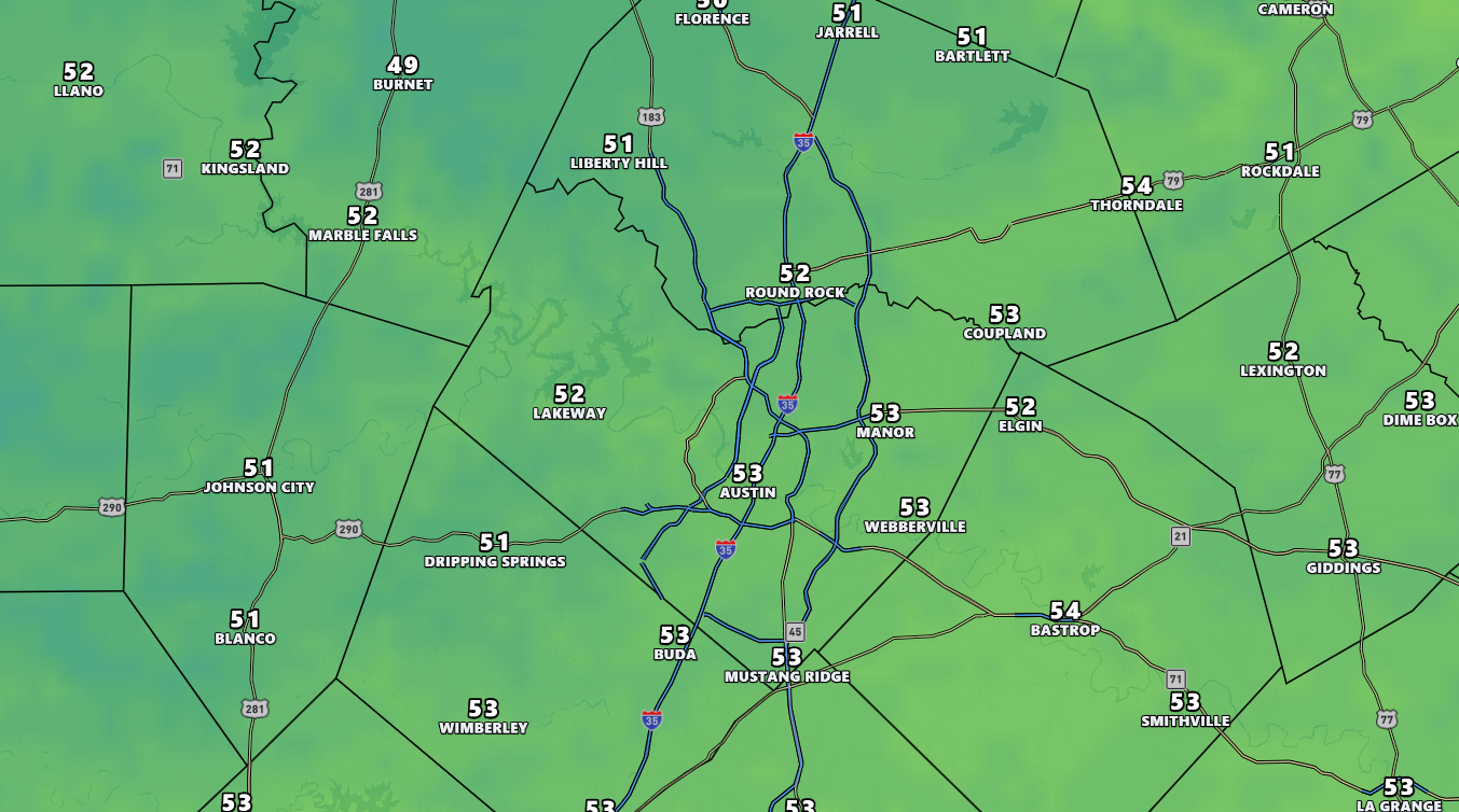
MONDAY HIGH · °F
Low 50s
NORMAL MID-NOV HIGH
~70°F
BELOW NORMAL
~20°F
WEEKEND RAIN · CAMP MABRY
1"+
Austin is set to record its coldest day since March 16 on Monday, November 16, as persistent overcast skies suppress afternoon temperatures into the low and mid-50s — roughly 20 degrees below the city's normal mid-November high of around 70°F. Hill Country communities may not escape the 40s.
Extraction Map
The mechanism is straightforward: thick cloud cover traps cool air at the surface and prevents solar heating from doing its usual work. Monday evening lows will hover in the mid-40s to low 50s, with no meaningful warm-up overnight. The pattern is a textbook illustration of how cloud physics, not Arctic intrusions or frontal passages, can deliver winter-like chill to Central Texas. Tuesday offers only modest relief. Thinning clouds should allow highs to reach the low to mid-60s, still well below seasonal norms. The real recovery arrives Wednesday as a shift to southerly winds pulls warmer Gulf air back into the region, pushing temperatures closer to the 70°F benchmark. Austin's Camp Mabry climate station recorded more than an inch of rain over the preceding weekend, offering some drought relief. The week ahead, however, looks predominantly dry. A few scattered showers could materialize Thursday, but without an organized storm system, meaningful rain chances remain low through Friday. A stronger weather system is being tracked for the following weekend, though forecast models disagree on its track. If it slides far enough south, it could deliver another round of measurable precipitation. For now, that remains speculative. The broader context: Central Texas routinely experiences sharp temperature swings in November as competing air masses jostle for position. This event is well within historical norms and carries no severe weather implications. The practical impact is limited to wardrobe choices and brief energy-demand bumps for heating. Separately, the Austin Statesman flags the possibility that an emerging El Niño pattern could bring snow to parts of Texas this winter, per the Farmers' Almanac forecast — a signal worth tracking but far from certain.
Worth reading?
RECOMMENDED
Score
60
/100
Neutral — a weather event with no generative or extractive dynamics. Brief heating demand increase is the only economic signal, and it dissipates within 48 hours.
What Is GRIN?
GRIN stands for Generativity, Resilience, Innovation efficiency, and Novelty openness. These four dimensions capture the essential characteristics of any memetic intelligence — whether a nation, a corporation, a religion, or a movement.
About GRINGenerativity
2/5
Resilience
3/5
Efficiency
3/5
Novelty
2/5
Extractive
0/5
Inverted
Does this create new capability or just redistribute existing value?
No generative signal. A 3-day cold snap creates no new capability; the only economic ripple is a brief uptick in residential heating demand.
Verified Facts (6)
Austin could see its coldest day since March 16, exactly eight months later
Highs in the low 50s — usual mid-November highs around 70 degrees, typical low near 50 degrees
Some Hill Country communities may not get out of the 40s, nearly 20 degrees colder than normal
More than an inch of rain fell over the weekend at Austin's Camp Mabry
Tuesday temperatures will still likely only make it into the low to mid-60s
Wednesday when temperatures in Austin return to more typical mid-November levels
More latest news
Read all